Skip main navigation
Zillow logo
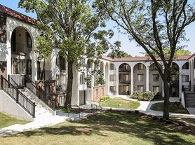
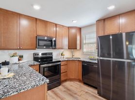
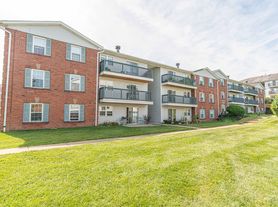
  • Building Photo
  • St. Luke's Surrey Place - Unclaimed

    14701 Olive Blvd, Chesterfield, MO 63017

    Located in Chesterfield zip code 63017
    Apartment building

    Neighborhood: 63017

    Areas of interest

    Use our interactive map to explore the neighborhood and see how it matches your interests.

    Building Location

    Nearby places

    Grocery & Shopping

    Five grocery and shopping spots within a 2 min drive, including Veritas Gateway To Food & Wine 0.2 mi away.

    Veritas Gateway To Food & Wine
    0.2 mi
    8 min
    2 min
    Fischer Frichtel
    0.2 mi
    6 min
    1 min
    Old House In Hog Hollow
    0.5 mi
    13 min
    1 min
    Phillips 66
    0.7 mi
    17 min
    2 min
    St. Louis Cigars
    0.8 mi
    19 min
    2 min

    Restaurants & Cafes

    Five restaurants and cafes within a 4 min drive, including Dierbergs School Of Cooking 0.2 mi away.

    Dierbergs School Of Cooking
    0.2 mi
    4 min
    1 min
    J-Ho's Cookery and Bakery
    0.3 mi
    10 min
    2 min
    Ice Cream Truck
    0.5 mi
    15 min
    2 min
    Old House In Hog Hollow
    0.5 mi
    13 min
    1 min
    Food Truck Thursday at Faust Park
    0.8 mi
    20 min
    4 min

    Fitness & Recreation

    Five fitness/gyms within a 4 min drive, including August G. Beckemeier Conservation Area 0.3 mi away.

    August G. Beckemeier Conservation Area
    0.3 mi
    9 min
    2 min
    Whimsical Woods
    0.4 mi
    11 min
    2 min
    Governor Bates Trail
    0.5 mi
    19 min
    4 min
    Thornhill @ Faust Park
    0.8 mi
    20 min
    4 min
    Faust Historic Village
    0.8 mi
    20 min
    4 min

    Hospitals & Medical

    Five medical facilities within a 3 min drive, including Surrey Place 0.1 mi away.

    Surrey Place
    0.1 mi
    1 min
    1 min
    St. Luke's Rehabilitation Hospital
    0.1 mi
    1 min
    1 min
    Chesterfield Veterinary Center
    0.8 mi
    18 min
    2 min
    Comfort Keepers
    0.9 mi
    22 min
    2 min
    Garden View Nursing Home
    1 mi
    28 min
    3 min

    Getting around

    Walk Score®
     / 100
    Car-Dependent
    Transit Score®
     / 100
    Some Transit
    Bike Score®
     / 100
    Somewhat Bikeable

    Nearby schools in Chesterfield

    River Bend Elementary School
    Grades K-5 • 1.6 miles
    6/10
    GreatSchools® Rating
    Test Score Rating
    8/10
    Student Progress Rating
    3/10
    Parkway Central Middle School
    Grades 6-8 • 1.7 miles
    6/10
    GreatSchools® Rating
    Test Score Rating
    9/10
    Student Progress Rating
    2/10
    Parkway Central High School
    Grades 9-12 • 1.7 miles
    8/10
    GreatSchools® Rating
    Test Score Rating
    8/10
    College Readiness Rating
    8/10

    Altheim, Bellefontaine, Hine and Lake sit across the suburban landscapes of Chesterfield and Town and Country, west of St. Louis, with wooded lots, rolling terrain and a humid four-season climate. The area’s defining landmark is Faust Park, with open green space, walking paths, historic buildings and the Butterfly House; nearby trails and parkland offer room to get outdoors. Dining and coffee are found in shopping centers along major roads, while Chesterfield Mall and other retail areas provide shopping options. Arts and entertainment include the outdoor performances and events at Chesterfield Amphitheater, alongside restaurants and movie theaters. Driving is the most practical way to connect these spread-out neighborhoods, with regional routes linking them to St. Louis and nearby destinations. For ZIP code 63017, median rent is $2,100 per month, with a typical range of $1,112 to $5,100.

    Powered by Zillow data and AI technology.

    Frequently asked questions

    Where is St. Luke's Surrey Place located, and what is the neighborhood like?

    St. Luke's Surrey Place is located at 14701 Olive Blvd, Chesterfield, MO. The surrounding area includes multiple restaurants and cafes within 2 miles, such as Dierbergs School Of Cooking, J-Ho's Cookery and Bakery, and Ice Cream Truck.

    What hospitals and medical facilities are near St. Luke's Surrey Place?

    The closest hospitals and medical facilities to St. Luke's Surrey Place include Surrey Place (0.1 miles away), St. Luke's Rehabilitation Hospital (0.1 miles away), and Comfort Keepers (0.9 miles away).

    What schools are assigned to St. Luke's Surrey Place?

    The schools assigned to St. Luke's Surrey Place include River Bend Elementary School, Parkway Central Middle School, and Parkway Central High School.

    What are the grocery stores and everyday shopping options near St. Luke's Surrey Place?

    St. Luke's Surrey Place is located near 2 grocery stores, including Dierbergs Market (1 mile) and Andrea's Fine Foods (2 miles). Additional shopping options, including Fischer Frichtel, are approximately 0.2 miles away.

    What colleges and universities are near St. Luke's Surrey Place?

    St. Luke's Surrey Place is located within 0.8 miles of Webster University.

    There are currently no available units for St. Luke's Surrey Place on Zillow. Find rental availability at nearby or similar apartment buildings below.
    Do you manage this property?

    Claiming gives you access to insights and data about this property.

    Building Photo
    Building Photo
    ]