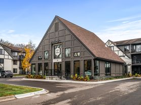
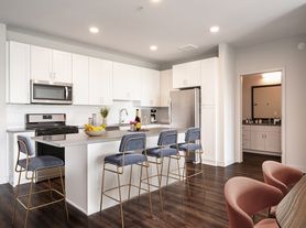
$1,445 - $1,880
Fees may apply
- 1+ bd
- 1+ ba
- 765+ sqft
Salem Green Apartments
For rent

Use our interactive map to explore the neighborhood and see how it matches your interests.
City Hall is a neighborhood in West St. Paul within ZIP code 55118, in the south-metro landscape of river bluffs, wooded stretches, and established residential streets. The area experiences Minnesota’s four distinct seasons, with cold, snowy winters and warm summers. West St. Paul’s civic center and nearby commercial corridors provide everyday shopping and dining, while cafés and casual restaurants offer places to pause between errands. Parks and local trails add outdoor options, including space for walks and fresh air; check individual sites for dog amenities and playground facilities. The Mississippi River and its scenic routes are close by, and regional roads and bus service connect the area with neighboring communities and central St. Paul. The rental market for ZIP code 55118 has a median rent of $1,425 per month and a typical range of $900 to $5,750.
Powered by Zillow data and AI technology.
Westview Park Community is located at 285 Westview Dr, West Saint Paul, MN. The surrounding area includes multiple restaurants and cafes within 2 miles, such as Culver's, Blvd Bar and Grille, and Chipotle Mexican Grill.
The closest hospitals and medical facilities to Westview Park Community include Mendakota Pediatrics (0.5 miles away), Miracle-Ear Hearing Aid Center (0.6 miles away), and Entira Family Clinics-West St Paul (0.6 miles away).
The schools assigned to Westview Park Community include Garlough Elementary School, Friendly Hills Middle School, and Two Rivers High School.
Westview Park Community is located near 6 grocery stores, including El Destino Market (0.2 miles) and Mi Pueblo Market (0.4 miles). Additional shopping options, including Target, are approximately 0.4 miles away.
Westview Park Community is located within 1 mile of Inver Hills Community College Veterans Center.
Claiming gives you access to insights and data about this property.