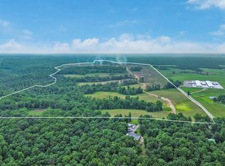
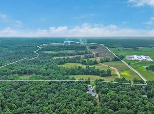
221.29 acres of contiguous, lightly improved land with exceptional infrastructure already in place and a clear, low-barrier path to development. Located just 2.4 miles (4 minutes) from I-40 and roughly 1 hour 30 minutes from Nashville, Mayland Farm is positioned for land developers, golf course developers, luxury home builders, and commercial buyers seeking scale in a market with minimal regulatory friction. Unincorporated Cumberland County has no county-wide zoning; 'Agricultural' is a property and tax classification only. Per written clarification from the Upper Cumberland Development District (October 2026), residential subdivisions, golf courses, and resorts can be pursued under current rules without rezoning. Development is governed solely by the Cumberland County Subdivision Regulations. Written guidance from the Upper Cumberland Development District (November 2026) outlines steps for dividing Mayland Farm: begin with an early informal consultation with Cumberland County Planning Commission staff to review a rough layout before formal surveys. The process typically includes informal consultation, preliminary plat, any required improvements, and final plat approval. Divisions of 5+ acres without new streets or utilities fall outside Planning Commission jurisdiction and can be confirmed with a preliminary sketch, offering additional flexibility for larger-lot or estate-style projects.The property offers strong site advantages for developers, including 80 acres of cleared, hay-ready land with gentle topography suitable for golf fairways, luxury home sites, or mini-farm estates. An 8-acre spring-fed stocked lake with dock and a $50,000+ professionally engineered spillway (fed by Funnel Creek) provides a ready amenity for a golf course, residential community, or private estate. Three additional ponds exist on site (two stocked with bass and bluegill; one spring-fed that holds water year-round).
Active
$7,745,150
2457 Mayland Rd, Crossville, TN 38571
--beds
--baths
221.29Acres
Farm
Built in ----
221.29 Acres Lot
$-- Zestimate®
$--/sqft
$-- HOA
What's special
- 352 days
- 182
- 21
Zillow last checked:
Listing updated:
Listed by:
April L Blankinship 865-324-3977,
Wallace 865-966-1111
Source: RealTracs MLS as distributed by MLS GRID,MLS#: 2976077
Facts & features
Property
Features
- Has view: Yes
- View description: Lake, Mountain(s)
- Has water view: Yes
- Water view: Lake
- Waterfront features: Pond, Lake Front
Lot
- Size: 221.29 Acres
- Dimensions: 110.645 x 110.645
- Features: Other, Private, Wooded, Rolling Slope, Level
- Topography: Other,Private,Wooded,Rolling Slope,Level
Details
- Parcel number: 05802001000
- Special conditions: Standard
Community & HOA
Location
- Region: Crossville
Financial & listing details
- Tax assessed value: $732,800
- Annual tax amount: $1,376
- Date on market: 11/23/2025
- Road surface type: Other, Paved
Estimated market value
Not available
Estimated sales range
Not available
Not available
Price history
| Date | Event | Price |
|---|---|---|
| 8/19/2025 | Listed for sale | $7,745,150+416.3% |
Source:  RealTracs MLS as distributed by MLS GRID #2976077 Report a problem | ||
| 5/29/2015 | Listing removed | $1,500,000 |
Source: CENTURY 21 Realty Group, LLC #876877 Report a problem | ||
| 3/5/2014 | Listed for sale | $1,500,000+71.4% |
Source: CENTURY 21 Realty Group, LLC #876877 Report a problem | ||
| 12/8/2009 | Sold | $875,000 |
Source: Public Record Report a problem | ||
Public tax history
| Year | Property taxes | Tax assessment |
|---|---|---|
| 2025 | $968 | $85,300 |
| 2024 | $968 | $85,300 |
| 2023 | $968 | $85,300 |
| 2022 | $968 -1% | $85,300 +36.5% |
| 2021 | $978 | $62,500 |
| 2020 | $978 | $62,500 |
| 2019 | $978 | $62,500 |
| 2018 | $978 +0% | $62,500 |
| 2017 | $978 +16% | $62,500 +13.2% |
| 2016 | $843 +2% | $55,200 |
| 2015 | $827 +0% | $55,200 +0% |
| 2014 | $827 | $55,199 |
| 2013 | $827 -0.2% | $55,199 |
| 2012 | $828 | $55,199 |
| 2011 | -- | $55,199 +4.1% |
| 2010 | $756 +11.3% | $53,020 +3.9% |
| 2009 | $679 +8.1% | $51,043 +0.8% |
| 2008 | $628 | $50,632 |
| 2007 | $628 -24.4% | $50,632 |
| 2006 | $830 -12.5% | $50,632 -12.5% |
| 2005 | $949 | $57,843 |
| 2004 | $949 +26.3% | $57,843 +10.9% |
| 2002 | $751 | $52,174 |
| 2001 | -- | $52,174 -60.2% |
| 2000 | -- | $131,030 |
Find assessor info on the county website
Monthly payment
Climate risks
Neighborhood: 38571

Similar homes
- $6,000,000600 acres0 Dripping Springs Rd, Monterey, TN 38574Lot/Land
 MLS ID #3311837, Rhonda Darrow. RealTracs MLS as distributed by MLS GRID
- $6,000,000600 acresDripping Springs Rd, Monterey, TN 38574Active

 MLS ID #1349866, Rhonda Darrow, Home Touch Realty, LLC. East Tennessee Realtors
- $6,000,000600 acresN/a Dripping Springs Rd, Monterey, TN 38574Lot/Land
 MLS ID #246172, Rhonda Darrow, Home Touch Realty LLC. UCMLS
- $3,950,000657.73 acres658 Peavine Firetower Rd, Crossville, TN 38571Lot/Land
 MLS ID #2930402, Tina Isham. RealTracs MLS as distributed by MLS GRID
- $3,950,000657.73 acres658AC Peavine Firetower Rd, Crossville, TN 38571Lot/LandMLS ID #234735, Tina Isham, Isham-Jones Realty. UCMLS
- $4,640,000349.8 acres6338 Golden Mountain Rd, Sparta, TN 38583Lot/LandMLS ID #246904, Wayne Russell, Highlands Elite Real Estate LLC. UCMLS
- $4,995,000610 acres1 Bilbrey Rd, Cookeville, TN 38506Lot/LandMLS ID #3623637, Jamie Spencer, CRB Broker/Owner. RealTracs MLS as distributed by MLS GRID
