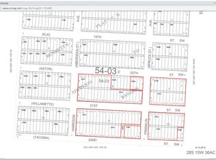
8.96 Acres in Bandon UGB with Existing Homestead Near Face Rock 8.96 contiguous acres west of U.S. Highway 101 in Bandon, Oregon, within the Bandon Urban Growth Boundary. The property is level, substantially cleared, and positioned along the planned east-west transportation corridor connecting Highway 101 with Bandon’s coastal neighborhoods. Five tax parcels comprise the property, including historically platted lots. The acreage also includes an existing homestead with a residence, driveway, well, septic system, underground electric service, and cable. The value and opportunity are primarily in the land, while the existing improvements provide useful on-site infrastructure. The property occupies a distinctive location between Highway 101 and the Face Rock / Beach Loop area. The planned 21st Street SW connection would improve east-west access through this part of west Bandon, with future city utility infrastructure anticipated through the corridor as surrounding development progresses. Following completion of the planned connection, the property would have a contemplated walking route of approximately one-half mile to beach access at Face Rock State Scenic Viewpoint. Face Rock Heights offers unusually large contiguous acreage in west Bandon, combining development potential, coastal proximity, existing on-site improvements, and direct relevance to the area’s evolving transportation and utility network.
This property is not currently displayed as for sale or rent on Zillow. This may be different from what's on other websites or public sources.